This report covers the growth and harvest of spring wheat In Kazakhstan. In October, winter rye and winter wheat, which are minor crops, were planted in the southern regions of the country. The crop conditions were generally below or close to average from July to October.
当前报告期涵盖了哈萨克斯坦春小麦的生长和收获期,南部地区的少量燕麦和冬小麦于10月开始播种。7月至10月作物长势总体低于或接近于平均水平。
Compared to the 15-year average, accumulated rainfall was above average (RAIN +23%), while radiation and temperature were below average (RADPAR -4%, TEMP -0.7°C). Precipitation reached 10 mm above the 15-year average in early and late July, and mid-August. The temperature fluctuated along the average level during this reporting period. The agro-climatic conditions resulted in a normal level for the potential biomass (BIOMSS).
与过去15年平均水平相比,累积降水量偏高23%,而平均气温和光合有效辐射分别偏低0.7°C和4%。全国平均降水在七月下旬和八月中旬距平偏高幅度超过10mm;平均气温整个监测期在平均值上下波动变化。农业气象条件作用使得潜在生物量处于平均水平。
The national average maximum VCI index was 0.72. The Cropped Arable Land Fraction (CALF) was down by 7% over the recent five-year average, and the Cropping intensity (CI) decreased by 18%. The spatial VCIx map matched well with the national crop condition development graphs. Crop conditions on about 21.5% of croplands were above average during the reporting period, mainly in southeastern areas of Akmola State and northeastern areas of Shyghys Kazakstan State. About 66.9% of croplands, which were distributed across the southern region, and most of Soltustik Kazakstan, Pavlodar, and Batysdy Kazakstan States, experienced poor crop conditions during the whole monitoring period except for mid-July. Remaining croplands (about 11.6%) experienced unfavorable crop conditions from July to mid-August, and then recovered to above average till end of October, mainly in the northern parts of Kostanay Sate.
Overall, due to below-average CALF and crop conditions, spring wheat production is estimated to be below average.
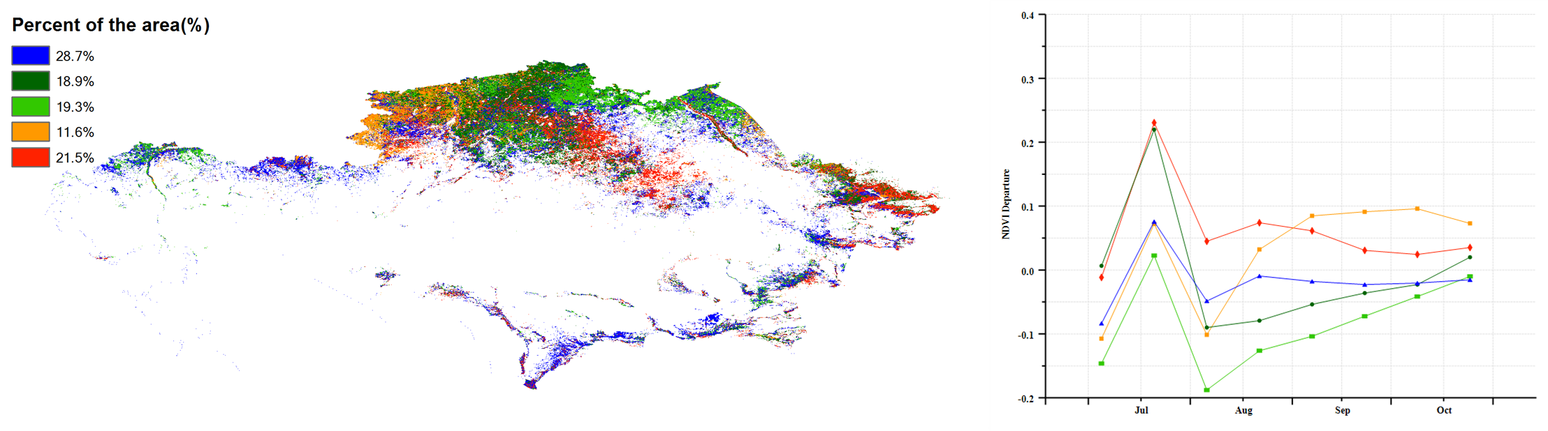
全国最佳植被状态指数(VCIx)平均为0.72, 耕地种植比例(CALF)较近5年平均水平下降7%,复种指数下降18%。VCIx空间分布与NDVI距平聚类分布图结果的一致性很高。大约21.5%的耕作区作物长势高于平均水平,主要分布在阿克莫拉州东南部和东哈萨克斯坦州东北部。大约66.9%的耕作区,包括南部区域,以及北哈萨克斯坦州、巴甫洛达尔州和北哈萨克斯坦州大部分地区,整个监测期除7月中旬外作物长势都低于平均水平。剩余的11.6%的耕作区自7月至8月中旬作物长势低于平均水平,随后直至10月底恢复到平均水平以上,这些区域主要分布在科斯塔奈州北部地区。
总的来讲,受耕地利用程度与作物长势均较往年差的影响,春小麦产量预计低于平均水平。
区域分析
Based on cropping systems, climatic zones and topographic conditions, four sub-national agro-ecological regions can be distinguished for Kazakhstan, among which three are relevant for crop cultivation: the Northern region (112), the Eastern plateau and southeastern region (111) and the South region (110).
基于耕作制度、气候分区以及地形条件,哈萨克斯坦可细分为三个子区域,其中有三个分区是农作物的主要种植区,分别是北部地区(112)、东部高原与东南部地区(111)和南部地区(110)。
The Northern region is the main spring wheat production area. Accumulated rainfall was above average (RAIN +20%), but RADPAR and temperature were below average. According to NDVI profiles, crop conditions were below average from July to September. The average VCIx for this region was 0.71, and the proportion of cultivated land was 8% lower than the average. Production is estimated to be below average.
在北部地区,与过去15年同期平均水平相比,降水量偏高20%,平均气温和光合有效辐射均低于平均水平。NDVI过程线结果显示7月至9月该区域作物长势低于平均水平。VCIx为0.71,且CALF较平均水平偏低8%。该区域作物产量预计低于平均水平。
Crop conditions in the Eastern plateau and Southeastern region were mostly below average from July to August, and close to average from September to October. The accumulated rainfall in the region was above average (+31%), while radiation and temperature were below average (RADPAR -6%, TEMP -1.5°C). The average VCIx for this region was 0.76, and CALF was below average by 6%. Production of spring wheat is unfavorable.
在东部高原和东南地区,作物长势在7月至8月低于平均水平,9月至10月接近于平均水平。降水量较平均水平偏高31%,光合有效辐射和平均气温分别偏低6%和1.5°C。VCIx为0.76,且CALF较平均水平偏低6%。该区域春小麦产量预计低于平均水平。
The South region received 40 mm of rainfall only, which was far below average (down 24%). The average VCIx for this region was 0.77. CALF was above average by 4%. NDVI profiles show the poor crop condition from July to October.
南部地区降水仅40mm,较平均水平显著偏低24%。VCIx为0.77。NDVI过程线结果显示7月至10月作物长势总体偏差。
图3.5 2020年7月-10月哈萨克斯坦作物长势
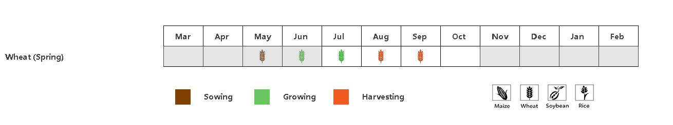
(a) 主要作物物候历
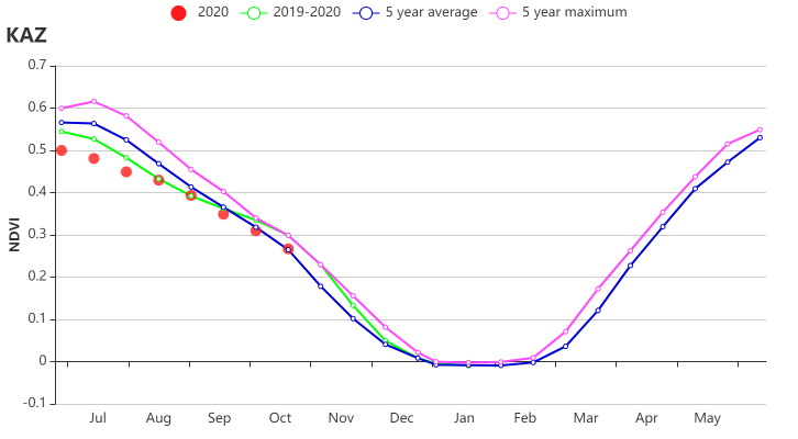
(b) 基于 NDVI 的作物生长过程线
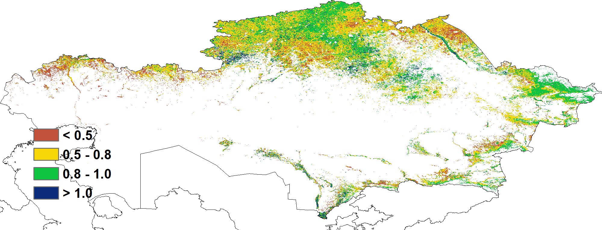
(c) 最佳植被状况指数
(d)降水时间过程线
(e)温度时间过程线
(f)NDVI 距平空间聚类图 (g) NDVI 距平聚类过程线
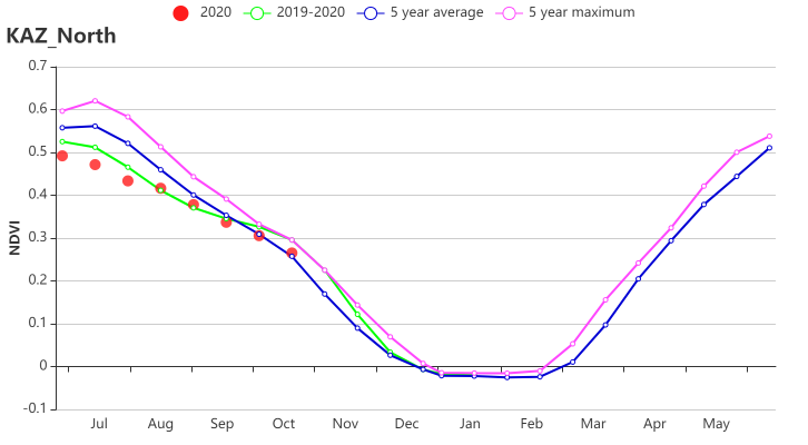
(h) 基于NDVI的作物生长过程线(哈萨克斯坦北部)
(i) 基于NDVI的作物生长过程线(哈萨克斯坦南部)
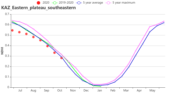
(i) 基于NDVI的作物生长过程线(哈萨克斯坦东部高原和东南部地区)
表3.1哈萨克斯坦农业生态分区2020年7月-10月与过去 15 年(15YA)同期农业气象指标
分区 | 累积降水 | 平均气温 | 光合有效辐射 | 潜在生物量 | ||||
当前季 (mm) | 15YA 距平 (%) | 当前季 (°C) | 15YA 距平 (°C) | 当前季 (MJ/m2) | 15YA 距平 (%) | 当前季 (gDM/m2) | 15YA 距平 (%) | |
北部地区 | 197 | 20 | 14.3 | -0.3 | 900 | -3 | 419 | 0 |
东部高原和东南部地区 | 284 | 31 | 13.5 | -1.5 | 1453 | -1 | 425 | -1 |
南部地区 | 40 | -24 | 20.6 | -1.1 | 1203 | -4 | 523 | 15 |
表3.2 哈萨克斯坦农业生态分区 2020年7月-10月与近5年(5YA)同期农情指标
分区 | 耕地种植比例 | 最佳植被状况指数 | 复种指数 | ||
当前季 | 5YA 距平 (%) | 当前季 | 当前季 | 5YA 距平 (%) | |
北部地区 | 77 | -8 | 0.71 | 100 | 0 |
东部高原和东南部地区 | 78 | -6 | 0.76 | 100 | -1 |
南部地区 | 58 | 4 | 0.77 | 100 | 0 |