本次报告涵盖了菲律宾从5月持续到10月的季风期后半段。报告期内,主季玉米的收割已于9月底完成,随后是主季稻的收割,而次季玉米和次季稻在10月份开始播种。与平均水平相比,菲律宾的累积降水量略微下降2%,平均气温增高0.4℃和光合有效辐射偏高3%。此外,全国的潜在生物量水平与平均水平相比略微增长3%。全国耕地种植比例几乎接近100%,最佳植被状况指数高达0.97,说明作物生长状况总体良好。
基于NDVI生长过程线,全国整体的作物状况在10月之前都接近平均水平。八月初略微低于平均水平,可能是由于卫星图像中的云覆盖或暂时的洪水造成的,而始于9月的NDVI下降,可能与频繁发生的台风有关。特别是第17号台风“Saudel”和第18号台风“Molave”造成了大面积的洪水。
NDVI的距平空间聚类图表明,主要分布在吕宋岛西海岸和中部地区以及棉兰老岛大部分地区的约52.7%的耕地,其NDVI在报告期内处于稳定且接近于平均水平。约17.1%的耕地,其NDVI在10月份前接近平均水平,而10月份下降幅度较大,高达0.4个NDVI单位。这些耕地主要分布在吕宋中部地区、卡加颜河谷南部地区和南科迪勒拉南部地区。虽然NDVI的大幅降低是由于卫星影像上台风带来的云雨遮盖造成,但是植被生长状况也受到了频发台风的很大影响,主要表现为NDVI曲线的下降。此外,在塔加洛南部地区和卡加颜河谷中部地区出现过一次NDVI异常,表现为10月中旬NDVI下降高达0.4个NDVI单元,而10月下旬恢复了0.35个NDVI单元。另外,在塔加洛南部地区和棉兰老岛南部地区总共约占18.7%的耕地,其NDVI在8月初下降超过0.35个NDVI单元,在8月中旬恢复了0.4个NDVI单元,也被认为属于NDVI异常。随后,这些区域的NDVI水平逐渐降低。这两种异常可能都是由卫星图像中的云量造成的,但10月份NDVI的总体下降趋势可能是受台风影响。总而言之,考虑到没有异常的NDVI和接近平均水平的农业气候指标,菲律宾在次报告期内的预期产量略低于平均水平。
区域分析
基于耕作系统、气候分区和地形状况,可将菲律宾的耕地归纳为3个主要的农业经济区,分别为低地农业区(北部岛屿)、丘陵农业区(玻尔岛、宿务岛和内格罗斯岛)和农林交错区(主要是南部和西部岛屿)。各分区的耕地种植比例较为稳定,几乎为100%,且最佳植被状况指数都高于0.96。
与平均水平相比,低地农业区平均气温偏高0.5℃,光合有效辐射偏高6%。虽然该地区累积降水量较平均水平偏低15%,但潜在生物量高于平均值约6%。同时,该区域耕作强度介于单次和一年2次之间,种植强度相较过去5年平均水平偏低2%。从NDVI生长过程线来看,该区域的NDVI在7月下旬低于平均水平,此后逐渐上升。但是,NDVI相对于平均水平在9月初又开始下降,且在本次报告末期,其与平均水平的偏离达到最大值。台风对作物有很大的影响,并导致了该地区的作物生长状况不佳。
与前15年平均水平相比,丘陵农业区在报告期内比正常情况下更加湿润,其累积降水量偏高9%,平均气温偏高0.5℃。该地区的光合有效辐射和潜在生物量均高于平均水平4%。此外,该区域耕作强度介于单次和一年2次之间,种植强度相较过去5年平均水平偏低3%。该地区的NDVI在7月低于平均水平,在8月中旬恢复到平均水平。但是,9月份NDVI再次下降,并在报告末期开始恢复。总体来说,该区作物的条件是不太乐观的。
农林交错区的累积降水量较平均水平偏高13%,平均气温较平均水平偏高0.2℃。该地区的光合有效辐射高于平均水平1%,潜在生物量接近平均水平。同时,该区域耕作强度介于单次和一年2次之间,种植强度相较过去5年平均水平偏低3%。NDVI生长过程线显示,该地区的NDVI在7月下旬低于平均水平,在8月中旬得以恢复。随后,NDVI在10月份再次降至平均水平以下。尽管NDVI与平均水平有差异,但偏差很小。因此,预期该地区的作物状况略低于或接近平均水平。
2020年7月-10月菲律宾作物长势
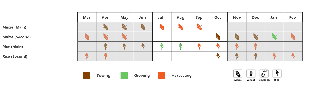
(a) 主要作物物候历


(b) 基于NDVI的作物生长过程线 (c) 最佳植被状况指数

(d) NDVI距平空间聚类图(与5年平均相比) (e) NDVI距平聚类过程线


(f) 温度(左)和降水量(右)的时间序列分布

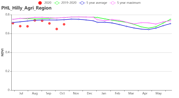
(g) 基于NDVI的作物生长过程线(低地农业区(左)和丘陵农业区(右))
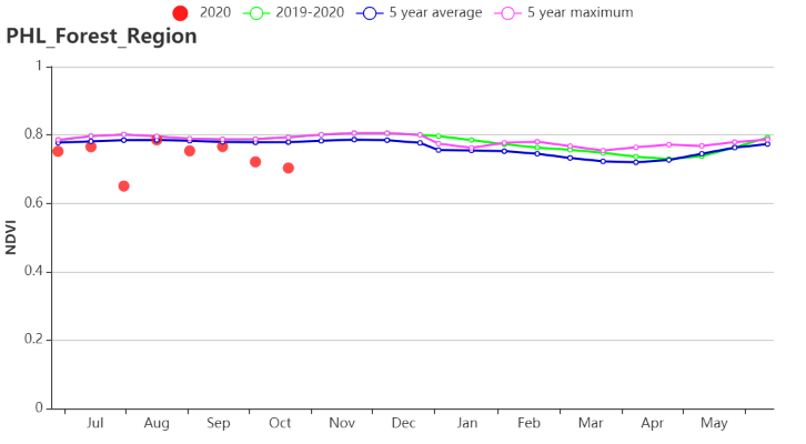
(h) 基于NDVI的作物生长过程线(农林交错区)
菲律宾农业生态分区2020年7月-10月与过去15年(15YA)同期农业气象指标
| 分区 | 累计降水量 | 平均气温 | 光合有效辐射 | 潜在生物量 | ||||||||||||||
| 当前值(mm) | 距平(%) | 当前值(℃) | 距平(℃) | 当前值(MJ/m2) | 距平(%) | 当前值(gDM/m2) | 距平(%) | |||||||||||
| 农林交错区 | 1609 | 13 | 25.4 | 0.2 | 1222 | 1 | 820 | 0 | ||||||||||
| 丘陵农业区 | 1773 | 9 | 27.1 | 0.5 | 1289 | 4 | 883 | 4 | ||||||||||
| 低地农业区 | 1609 | -15 | 25.9 | 0.5 | 1235 | 6 | 833 | 6 | ||||||||||
菲律宾农业生态分区2020年7月-10月与近5年(5YA)同期农情指标
| 分区 | 耕地种植比例 | 复种指数 | 最佳植被状况指数 | |||||||||
| 当前值(%) | 距平(%) | 当前值(%) | 距平(%) | 当前值 | ||||||||
| 农林交错区 | 100 | 0 | 135 | -3 | 0.97 | |||||||
| 丘陵农业区 | 100 | 0 | 121 | -3 | 0.99 | |||||||
| 低地农业区 | 100 | 0 | 142 | -2 | 0.97 | |||||||