
 English
 中文
中文
Bulletin
CropWatch bulletinMenu
Authors: 超级管理员 | Edit: tanshen
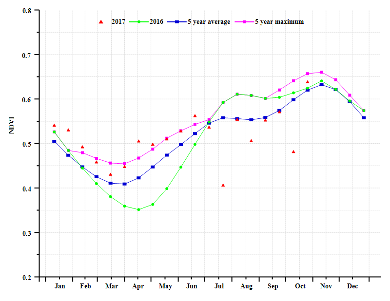
The reporting period covers the sowing of the main wet season rice in Cambodia, which started from late June (depending on the area), as well as the growing and harvesting period of maize. No dry season rice was cultivated in this monitoring season. Nationwide, crop condition before November was close to the average of the recent five years, with some fluctuation in October but recovering before November.
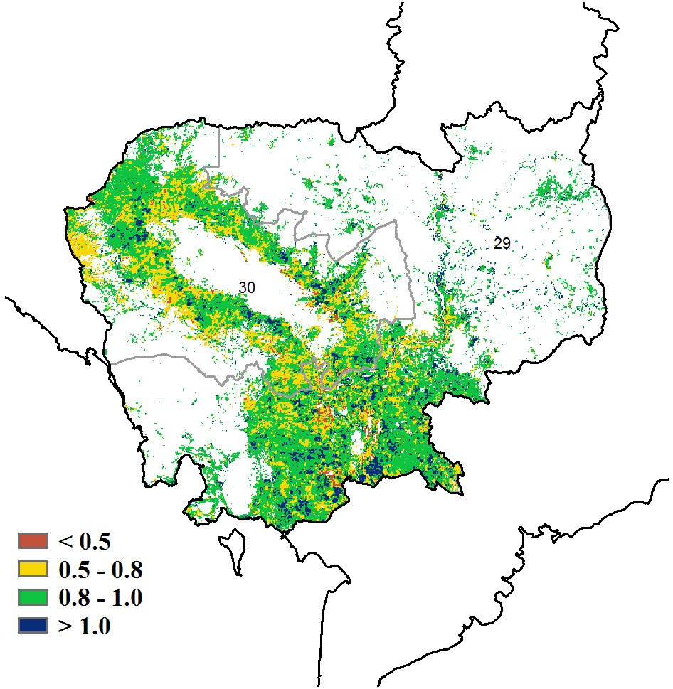
With 1152 mm of precipitation, rainfall (RAIN) in the country was only 2% down compared to average, following a 7% increase of rainfall during the previous monitoring period. Near average rainfall was accompanied by average temperature (TEMP, -0.5°C) and radiation (RADPAR, -3%). All the climate indicators combined resulted in an average biomass production potential (BIOMSS, +0.7%), which points at an average crop condition. The cropped arable land fraction decreased 1% on the national level. According to the VCIx distribution map, fair crop condition (VCIx>0.5) occurs over most of the country, except some sparse areas around Tonle Sap representing less than 5% percent of croplands. Over 50% percent of the crop area showed good crop health condition nationwide (VCIx>0.8), which means the absence of any agricultural disasters this season. NDVI clusters confirm the VCIx map: Of the total cropping area, 38.1% shows a slight increase in NDVI compared with average, while about 50% shows fluctuations while remaining close to average. Only 1.2% percent of croplands near the northeast shore of Tonle Sap show a marked decrease. It cannot be excluded that the decrease results from cloud contamination of the NDVI image.
Overall, CropWatch puts the rice production estimate for the country 2.4% above that of last year. For maize, the increase is even higher, at +4.1%.
Regional analysis
Based mostly on climate differences, two agro-ecological regions can be distinguished in Cambodia. Weather in the Tonle Sap lake area (especially rainfall and temperature) is mainly influenced by the lake itself. In the second area, named the main crop area and covering the border areas with Thailand and Laos in the north and Vietnam in the east, climate conditions are based on the monsoon.
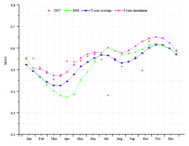
Both regions display similar NDVI profiles in this monitoring period. The profile in the Tonle Sap lake area, however, is slightly lower than the five-year average because of an obvious decrease in rainfall near Tongle Sap (987 mm; a 10% decrease). Similar to the NDVI profile of the whole country, the NDVI for the region recovered to the five-year average after fluctuations in October. The two sub-regions also display similar radiation (RADPAR about +3%) and temperature (TEMP about -0.5°C) departures. Water deficit led to a 2% decrease in BIOMSS in the lake area.



Cambodia agroclimatic indicators by agro-ecological region, current season's values and departure from 15YA, July to October 2017
| Region | RAIN | TEMP | RADPAR | |||
| Current | Departure from 15YA (%) | Current | Departure from 15YA (°C) | Current | Departure from 15YA (%) | |
| (mm) | (°C) | (MJ/m2) | ||||
| Main cropping area (Cambodia) | 1268.0 | 3.0 | 27.9 | -0.5 | 956.0 | -3.0 |
| Lake plains (Cambodia) | 987.0 | -10.0 | 28.1 | -0.6 | 982.0 | -2.0 |
| Region | BIOMSS | CALF | Maximum VCI | ||
| Current (gDM/m2) | Departure from 5YA (%) | Current | Departure from 5YA (%) | Current | |
| Main cropping area (Cambodia) | 2470 | 3.0 | 0.9 | -1.0 | 0.9 |
| Lake plains (Cambodia) | 2258 | -2.0 | 1.0 | -1.0 | 0.9 |
CropWatch-estimated wheat production for Cambodia in 2017 (thousand tons)
| Crops | Production 2016 | Yield variation (%) | Area variation (%) | Production 2017 | Production variation (%) |
| Maize | 779 | 0.10% | 0.10% | 780 | 4.10% |
| Rice | 8588 | 3.40% | 1.30% | 8792 | 2.40% |