在监测期内,缅甸正处于季风季节,其中主稻(季风水稻)在7月至9月之间生长,并于10月开始收获,而玉米和小麦在9月和10月开始播种。在监测期间,该国的作物长势低于平均水平。
与过去15年平均水平相比,累计降水(-4%)和光合有效辐射(-3%)均明显偏低,而平均气温(+0.6ºC)则有所偏高。受农气条件影响,潜在生物量略微偏低2%,耕地种植比例接近近5年平均水平。复种指数也与近5年平均水平持平。除7月中旬和9月初以外,NDVI值在整个监测期内均低于平均水平。监测期内该国的最佳植被状况指数为0.92。
在监测期内,该国一半以上的耕地的作物长势低于平均水平,这些耕地主要分布在中部平原和山区、包括曼德勒、马圭、实皆南部和掸邦。此外,19.7%的耕地的NDVI距平值在7月至9月中旬为正,23.2%的耕地的NDVI距平值在7月至9月初也显示正值。这些耕地大多位于三角洲和南部沿海,包括仰光、勃固、伊洛瓦底、马圭、德林达依以及孟邦和克钦邦等地区。在中部干旱区域,最佳植被状况指数小于0.8,而在其他地区的值较高。
区域分析
根据种植系统、气候分区以及地理条件,可将缅甸划分为三个农业生态区域,分别是中部平原、山区以及三角洲和南部沿海。
中部平原累计降水较过去15年平均水平明显偏低( -21%),光合有效辐射偏低1%,平均气温则偏高1ºC。潜在生物量较平均水平偏高1%,是三个分区中唯一增长的分区。耕地种植比例监测结果显示,95%的耕地得到充分利用,仅比近5年平均水平偏低2%。在整个监测期内,NDVI值始终低于平均水平。最佳植被状况指数为0.89。该分区的作物长势较差。
山区的累计降水(1936 mm)为三个分区中最高,且较过去15年平均水平偏高9%。光合有效辐射偏低5%,而平均气温偏高0.4ºC。潜在生物量比平均水平偏低3%。本监测期内的耕地几乎全部种植。 NDVI总体低于平均水平,仅在6月中旬和10月才接近平均水平。最佳植被状况指数为0.97。该分区的作物长势低于平均水平。
三角洲和南部沿海在监测期内正处于干燥的季风时期,累计降水远远低于过去15年平均水平(-25%)。平均气温偏高0.3ºC,光合有效辐射则接近平均水平。潜在生物量也处于平均水平。由于该分区绝大部分耕地都有所灌溉,因此降水不足对作物生长和产量的影响很小。耕地种植比例比平均水平偏高1%,最佳植被状况指数为0.93。与另外两个分区类似,该分区的作物长势也低于平均水平。
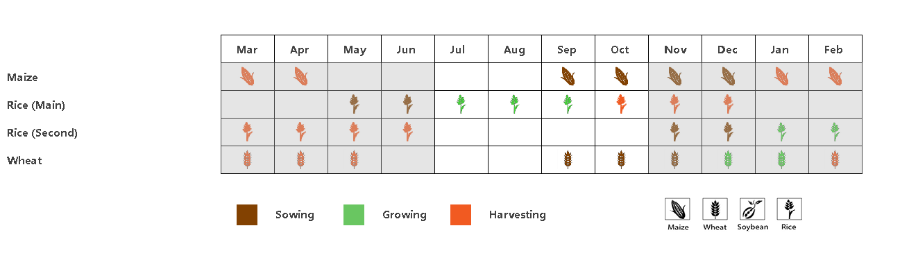
(a) 主要作物物候历
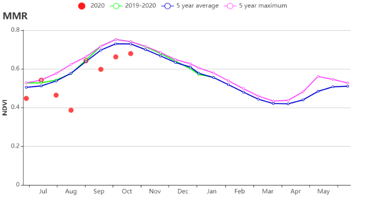
(b) 基于NDVI的作物生长过程线
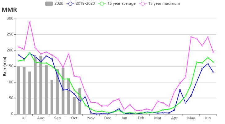
(c) 降水时间过程线
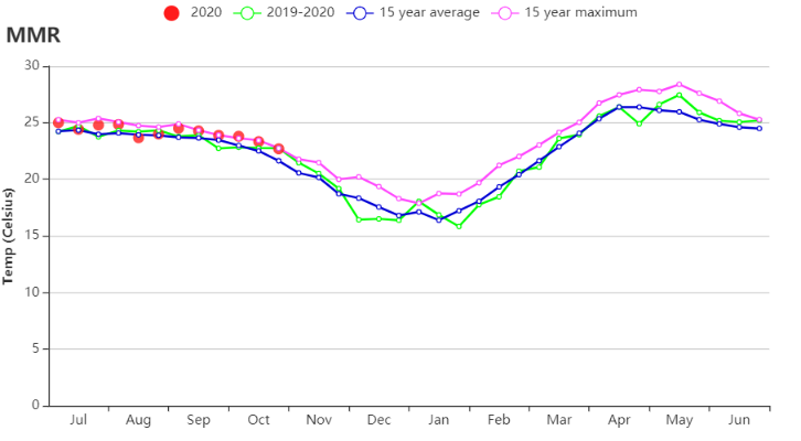
(d) 温度时间过程线

(e) 最佳植被状况指数
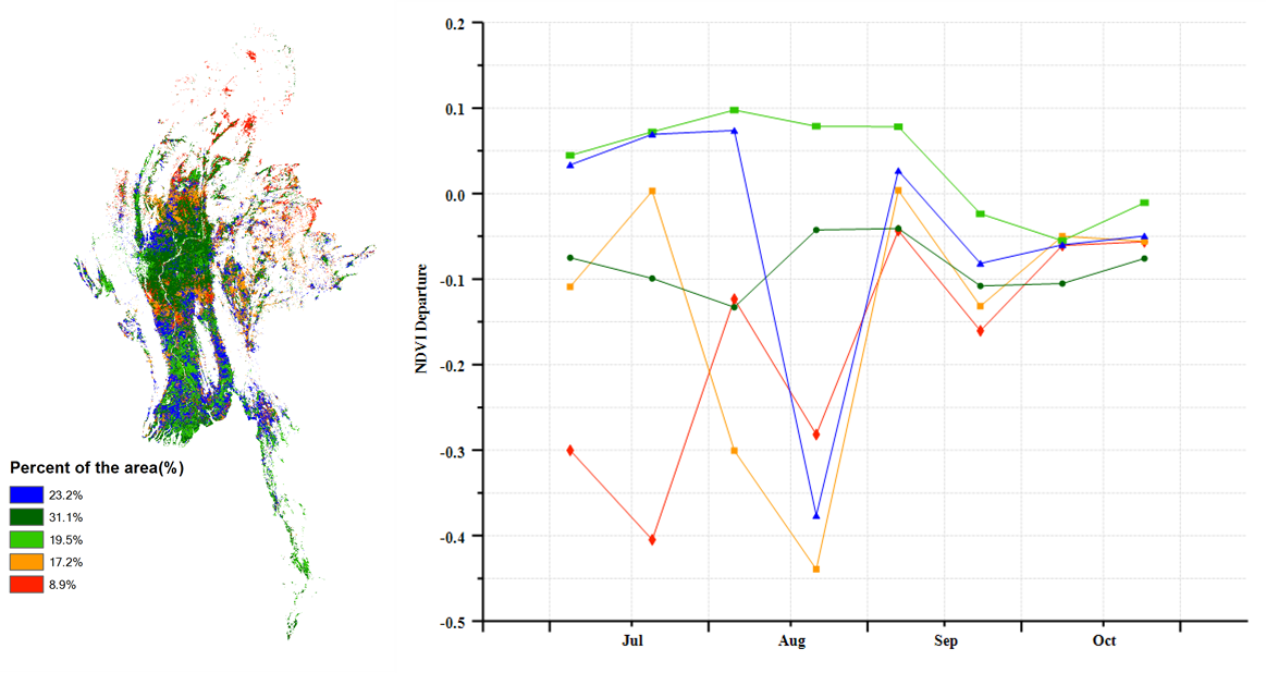
(f) NDVI距平空间聚类图(与5年平均相比) (g) NDVI距平聚类过程线
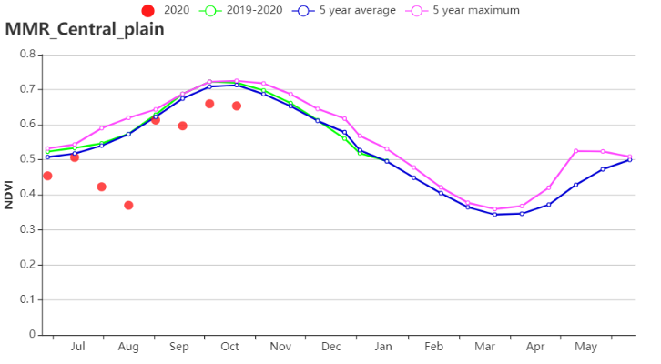

h) 基于NDVI的作物生长过程线(中部平原(左)和山区(右))
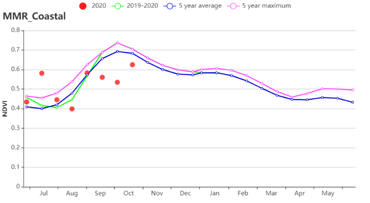
(i) 基于NDVI的作物生长过程线(三角洲和南部沿海)
表3.51 缅甸农业生态分区2020年7月-10月与过去15年(15YA)同期农业气象指标
分区 | 累计降水 | 平均气温 | 光和有效辐射 | 潜在生物量 | ||||
当前值(mm) | 距平(%) | 当前值(°C) | 距平(°C) | 当前值(MJ/m2) | 距平(%) | 当前值(gDM/m2) | 距平 (%) | |
中部平原 | 933 | -21 | 25 | 1 | 1031 | -1 | 670 | 1 |
山区 | 1936 | 9 | 22.9 | 0.4 | 913 | -5 | 559 | -3 |
三角洲和南部沿海 | 1632 | -21 | 26 | 0.3 | 1078 | 0 | 733 | 0 |
表3.52 缅甸农业生态分区2020年7月-10月与近5年(5YA)同期农情指标
分区 | 耕地种植比例 | 复种指数 | 最佳植被状况指数 | ||
当前值(%) | 距平(%) | 当前值(%) | 距平(%) | 当前值 | |
中部平原 | 95 | -2 | 105 | -1 | 0.89 |
山区 | 99 | 0 | 109 | 1 | 0.97 |
三角洲和南部沿海 | 95 | 1 | 125 | 1 | 0.93 |